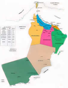
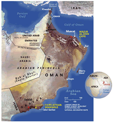
Oman is located in the southeastern quarter of the Arabian Peninsula. The geographic location contributed to the isolation of inner Oman. Historically, the country's contacts with the rest of the world were by sea. The Al-Hajar Mountains with the highest peak Jabal al-Akhdar (3,074 m) form a barrier between the fertile coastal plain Al-Batinah and the desert. The most important cities of Oman - Muscat, Sohar and Sur- are located on Al-Batinah. In the southwest part of the country is another fertile coastal region with the city Salalah.
The land area of Oman shows varying topographic features: valleys and desert account for 82 % of the land mass; mountain ranges for 15 %; and the coastal plain for 3 %. Natural features divide the country into seven distinct areas: The peninsula Musandam, the Al-Batinah coastal plain, the Muscat-Matrah coastal area, the Al-Hajar Mountains, the inner Oman, the eastern coastline including the island of Masirah and the Dhofar region.
The exclave Musandam is an extension of the Al-Hajar Mountains and borders the Strait of Hormuz, which links the Persian Gulf with the Gulf of Oman. It is separated from the rest of the sultanate by a strip of territory belonging to the United Arabian Emirates.
The narrow, well-populated coastal plain Al-Batinah runs 140 km from the northern border of the sultanate southeast to the town of As Sib. Across the plains, a number of wadis descend from the Al-Hajar Mountains, conducting enough water to enable fruit and vegetable growth.
South of As Sib, the coast changes character. For about 175 km it is barren and bounded by cliffs almost its entire length. There is no cultivation and little habitation. Although the deep water off this coast renders navigation relatively easy, there are few safe anchorages. The two best are at Muscat and Matrah, where natural harbours facilitated the growth of cities centuries ago.
South of the coastal plain on the other side of the Al-Hajar Mountains lies the inner Oman with parts of rocky desert and sand dunes leading west into the Rub al Khali, the largest sand desert in the world. The eastern coastline, where low hills and wastelands meet the Arabian Sea for long distances is desolate.
The Dhofar region forms the south-western part of the sultanate and borders to Yemen. Located on the fertile coastline is the province capital Salalah, which was the permanent residence of Sultan Said bin Taimur Al Said.
To read more about Oman's geography, please download the essay "Introduction to Oman" by Felix Richter.
Continue to Climate".
please klick here
to enlarge this map