| Archaeology |
| History |
| Urban Planning |
| Agriculture |
| Landscape Ecology |
 |
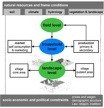
Landscape modelling and land use scenarios Objectives: Integrated socio-economic and ecological evaluation of the land use system, modelling of land use scenarios and development of recommendations for sustainable management strategies. Contact Person: Prof. Dr. Andreas Bürkert and Prof. Dr. Eva Schlecht, Institute of Crop Science, University of Kassel, Germany Email: tropcrops@uni-kassel.de Scientific staff: Dr. Katja Brinkmann, Dr. Uta Dickhoefer, Dr. Eike Luedeling Study area: Three selected villages at Al Jabal al Akhdar Duration: 2008-2009 The results of the disciplinary studies of Agriculture and Landscape Ecology provide the foundation for a spatially explicit landscape model, which describes and explains the system’s functioning. Data incorporating the physical conditions, land use, working activities, products and produced values are combined and transformed, resulting in aggregated data, economic and ecological indicators and descriptors. Within a GIS, the terrain, land uses, soils and vegetation were analysed and combined with supplementary and non-spatial data. The three main parts of the model are:
The modeling approach is used to create future landscape scenarios with different agricultural management strategies, including social and economic information’s. For the evaluation of the different scenario results and the changes when compared to the current situation, the economic and ecological indicators are depicted as an amoeba diagram. The different management strategies of a scenarios, such as an enlargement of pomegranate cultivation, an intensification of livestock production or the abandonment of land use as a result of decreasing population density, are evaluated in terms of sustainability, that is maintenance of productivity and income, and of biodiversity. A comparative analysis and evaluation of the scenarios is used to define recommendations for a sustainable regional development.
|
|||||||||||||||||||